- What is a map projection?
- Properties of a map projection
- Types of map projections
- Examples of map projections
- Why are map projections distorted?
We explain what a cartographic projection is, its function in the creation of maps and its properties. In addition, we give you several examples.
What is a map projection?
In geography, a map projection (also called a geographic projection) is a way of visually representing a portion of the Earth crust, which performs an equivalence between the natural curvature of the planet and the flat surface of a Map. It consists, fundamentally, in "translating" a three-dimensional representation into a two-dimensional, distorting the proportions of the original as little as possible.
It is a procedure typical of the creation of maps by cartographers, who must be guided by the coordinate system that makes up the maps. meridians and parallels terrestrial to construct a spatial representation that is faithful to the proportions of the curvature of the planet.
This, however, cannot be done without a certain margin of error, so the projections are studied in order to reduce distortion as much as possible and preserve, above all, the three fundamental aspects of a map: the distance, surface and shape.
There are different possible cartographic projections, that is, different methods Y procedures to represent the dimensions of the Earth (or a portion of its surface) in two dimensions, since this has been a topic that has occupied geographers since ancient times. In that sense, none is "more faithful" than another, but they present different problems geometric and emphasize different aspects of representation.
Properties of a map projection
All cartographic projections have characteristic features that have to do with the type of transformation or the geometric procedure used to make it. Thus, a geographic projection can have one or two of the following three properties, but in no case can it fulfill all three at the same time:
- Equidistance. The projection is faithful to the distances of the original, that is, it does not enlarge or shrink them, but maintains its proportion on the scale correspondent.
- Equivalence. The projection is true to the areas of the original surfaces, that is, it does not distort the sizes and dimensions of the surfaces.
- Accordance. The projection is true to the shapes and angles of the original, that is, it does not distort the silhouette or appearance of the represented surface.
In each projection, it is sought to comply as much as possible with these three fundamental properties, although generally one is sacrificed more than another depending on the specific usefulness of the projected map. For example, if it is a world map either planisphere school, in general the form of the words is respected continents (conformity) than the distance between them (equidistance) and the surface of each one (equidistance).
Types of map projections
To classify cartographic projections, the criterion of the geometric figure that inspires it, that is, if the projection is cylindrical, conical, azimuthal or if it combines aspects of these three categories.
- Cylindrical projections. As their name indicates, they are the projections that use an imaginary cylinder as the surface of the map.Located secant or tangent to the spherical surface of the planet, this cylinder has good conformity (respects the shapes), but as we move away from the equator, a greater and more noticeable distortion is produced in terms of distances and surfaces. Even so, by preserving the perpendicularity between meridians and parallels, it is a simple and useful type of projection, widely used in navigation.
- conical projections. In a similar way to the cylindrical ones, these projections are obtained by locating the terrestrial sphere within the interior curvature of an imaginary tangent or secant cone, on which the parallels and meridians will be projected. This type of projection has the virtue of turning the meridians into straight lines that start from the pole, and the parallels into concentric circles within the cone. The map obtained is ideal for representing the middle latitudes, because it presents greater distortion as one moves towards the poles.
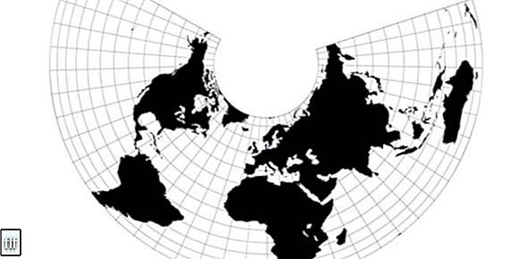
- Azimuthal or azimuthal projections. Also called zenithal projections, they are obtained by placing the terrestrial sphere on an imaginary plane, tangent to the sphere itself, on which the meridians and parallels are projected. The point of view obtained corresponds to the view of the world from the center of the Earth (gnomonic projection) or from a distant planet (orthographic projection). These projections are ideal for preserving the relationship between the poles and the hemispheres, so they are faithful in high latitude regions; but they present a growing distortion the greater the distance between the tangential point of the plane and the sphere, so that they are not suitable for faithfully representing the equatorial region.
- Modified projections.Also called combined or mixed projections, they are those that incorporate different aspects of the previously listed projections, and try to achieve a faithful representation of the earth's surface through breaking the continuity of the map and the mathematical construction of a square that encompasses the same surface of a circle: a counterintuitive procedure, but one that allows experimenting with voluntary deformations of the terrestrial meridians and parallels, thus obtaining new and impossible results using the rest of the projection types.
Examples of map projections

The main and best known cartographic projections of the Earth (that is, a world map) are:
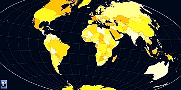
- The Mercator projection. Created by the German geographer and mathematician Gerardus Mercator (1512-1594) in 1569, it is one of the most used terrestrial projections in history, especially in the making of maps for navigation during the 18th century. It is a cylindrical type projection, practical and simple, but it deforms the distances between the terrestrial meridians and parallels by turning them into parallel lines, which increases the distance between one and the other as you move towards the pole. Added to this is a shrinking of the equatorial regions, which allows, for example, Alaska to look more or less the size of Brazil, when the latter is actually almost five times its size. This causes Europe, Russia and Canada to have a much more prominent role in the representation of the globe, for which the map has been accused of being Eurocentric.
- Lambert's projection. Also called “Lambert Conformal Projection” to distinguish it from other projections made by the Franco-German physicist, philosopher and mathematician Johann Heinrich Lambert (1728-1777), it is a conical projection created in 1772.It is obtained using two reference parallels that intersect the globe and act as sides of the cone, which allows zero distortion along the parallels, although this distortion increases when moving away from them. The meridians, on the other hand, become curved lines of great accuracy. The result is a projection with very high conformance, which is often used for aircraft flight charts, even though world maps produced with it are usually only suitable for one hemisphere at a time.
- The Gall-Peters projection. Created by Scottish clergyman James Gall (1808-1895) in 1855, this projection first appeared 30 years later in the Scottish Geographical Review (Scottish Geographical Magazine). But its popularization and implementation corresponded to the German filmmaker Arno Peters (1916-2002) and for that reason it bears the name of both. It is a projection that seeks to correct the defects of the Mercator projection, and for that, it places more emphasis on equivalence: it projects the terrestrial sphere in an imaginary cylinder, which is then stretched to double its own magnitude.
- The van der Grinten projection. Created in 1898 by the German-American cartographer Alphons J. van der Grinten (1852-1921), it is not a conformal or equivalent projection, but rather an arbitrary geometric construction on the plane. It uses the same Mercator methods, but considerably reduces its distortions, which are reserved for the poles, subject to a maximum degree of inconformity. This projection was adopted by the National Geographic Society in 1922, until its replacement in 1988 by the Robinson projection.
- Aitoff's projection.Proposed in 1889 by the Russian cartographer David Aitoff (1854-1933), it is a slightly equivalent and slightly conformal zenithal or azimuthal projection, built from the distortion of the horizontal scale to turn the terrestrial sphere into an ellipse twice as wide as the high. It is a constant scale on the equator and the central meridian of the planet, which inspired Ernst Hammer to propose a similar model in 1892, known as the Hammer projection, but of little use.
- Robinson's projection. Created in 1961 by the American geographer Arthur H. Robinson (1915-2004), it arose as a response to the debate regarding the fairest representation of the planet that occurred in the mid-20th century. Its purpose was to show the world map in a simple but unreliable way on a semi-cylindrical plane, so that it is neither equidistant, nor equivalent, nor conformal, but rather assumes its distortions (most important in the polar region and at high latitudes) based on a cultural consensus, which would produce attractive images of the entire world, without emphasizing any continent. This projection was widely used by the National Geographic Society until its replacement in 1998 by the Winkel-Tripel projection.
- The Winkel-Tripel projection. It is a modified azimuthal geographic projection, proposed by Oscar Winkel in 1921, from the combination of the Aitoff Projection and an equidistant cylindrical projection. This projection was adopted by the National Geographic Society in 1998, and since then it has been considered the best model of terrestrial representation to date.
Why are map projections distorted?
The phenomenon of distortion is unavoidable in any type of projection, although it can be reduced or hidden to a certain extent.This is due to a geometric problem: it is impossible to faithfully translate a spherical surface into a flat one, preserving its distance, shape and surface aspects when going from three dimensions to two.
A good way to verify this phenomenon is to imagine that we are standing on one of the terrestrial poles and that we walk in a straight line towards the equator, guided by any meridian. Once there, we walk a distance in a straight line on the equator and then we return to the pole in a straight line, guided by the corresponding meridian.
The trajectory that we have described in our tour composes a spherical, curved triangle, which has two right angles (that is, 90° opening) and a third smaller angle, but greater than 0° opening. Therefore, the sum of the angles of this triangle is greater than 180°, which is geometrically impossible for any plane triangle. The answer to this enigma lies precisely in the necessary distortion suffered by the triangle described when it is on the surface of a sphere.