We explain to you what the relief of Europe is like and the characteristics of its geographical regions. Also, its highest peaks.
What is the relief of Europe like?
The European continent, the western region of the great continental block that is Eurasia, is one of the continents smallest in the world with 10,530,751 km2 of surface. It extends from the ocean Atlantic (west), Arctic Ocean (north) and Mediterranean Sea (south), to the mountain ranges of the Urals and the Caucasus, the Caspian Sea, the Black Sea and the Straits of the Bosphorus and Dardanelles (east), geographical elements that separate Europe from Asia.
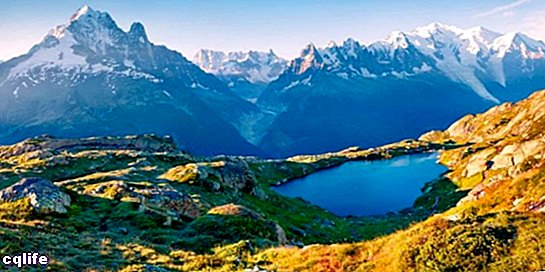
However the relief Europe is relatively straightforward. Broadly speaking, it consists of a large plain central covering 66% of the territory European, not exceeding 200 meters high, dotted with moutains low, some old and eroded, and others young and taller. Its highest points are Elbrus (5,633 masl), Mont Blanc (4,807 masl) and Mulhacen (3,478 masl).
The presence of sea On the continent, on the other hand, it is constant: Europe has more than 43,000 km of coasts, in which peninsulas (Jutland, Italy, Scandinavia, etc.), capes (Finisterre, Matapan, San Vicente, Norte, etc.) abound. ), gulfs (Finland, León, Genoa, Venice, Vizcaya, etc.), straits (of Gibraltar, English Channel, Bosphorus, etc.) and fjords.
The things that can be classified into two: the coasts of the Baltic Sea and North Sea, and the Mediterranean coasts that separate Europe from northern Europe. Africa. The latter have had a singular historical importance in the development of the ancient civilizations region of.
The relief of Europe is usually organized around several large regions or physiographic sets, which are:
The Great European Plain. Free of elevations except for a few small ones in its interior, this geographical feature extends from the Pyrenees and the shores of the North Atlantic Ocean, to the Ural Mountains in the east. It is relatively narrow in the western region (about 300 km), while towards the north it widens, especially towards eastern Russia.
This immense plain is crossed by different rivers such as the Loire, the Rhine, the Vistula, the Northern Dvina, the Daugava, the Volga, the Don and the Dnieper, and is commonly divided into two subsets: the northern European plain and the eastern European plain, although this division responds more to a historical and cultural criterion, than geomorphological.
- The North European Plain. Also known as the Central European Plain, it is located south of the North and Baltic Seas, both separated by the Jutland Peninsula. It does not exceed 200 meters in elevation, and is shared by the territories of Belgium, the Netherlands, Germany, Denmark, Poland, the Czech Republic and some regions of England that were part of the group in the past.
- The eastern European plain. Also known as the Russian plain, it extends for 4 million square kilometers with an average height of 170 meters above sea level. It covers the territory of Russia, Estonia, Latvia, Lithuania, Belarus, Ukraine, Poland, Moldova, Armenia and part of Kazakhstan.
The Hercynian and Caledonian massifs. These are some of the oldest structures in Europe, such as the western and northern shields of the continent, which emerged during the Precambrian. Hard materials and rounded, eroded shapes abound in them. Some examples of these massifs are the French Central Massif, the Iberian Massif and the Scandinavian Shield.
The alpine arches. The Alps are a Mountain range of young mountains located in the center of Europe, among which are important elevations, such as Mont Blanc. It is usually divided into three regions:
- The Western Alps, ranging from the Mediterranean to the Valais.
- The central Alps, ranging from the Valais to the Grisons.
- The eastern Alps, spanning the remaining mountain range, stretching east and south, all the way to the Carpathians.
The eastern mountain ranges. This set includes two different independent mountain formations, each of which ends the European continent and serves as a boundary. We refer to:
- The Ural Mountains, a long and slightly elevated mountain range that acts as a natural border between Europe and Asia, extending about 2,500 km in a north-south direction, until it culminates in Mount Narodnaya (1,895 meters above sea level). The Urals are some of the oldest mountains in the planet Earth, whose origin dates back to 250 to 300 million years ago.
- The Carpathian Mountains, located in Eastern Europe and forming an arc 1,600 km long and 150 km wide, is the second longest mountain range on the continent, after the Scandinavian Alps. The mountain range stretches across the borders of Austria, the Czech Republic, Slovakia, Poland, Ukraine, Romania, Serbia, and part of Hungary. Its highest peak exceeds 2,600 meters in height.
The Mediterranean plains. Interrupted by the Alps and by the Iberian and French massif, these are narrow and very limited plains that border the European coast on the Mediterranean Sea. They have a presence in the Italian, Spanish, French, Greek and Portuguese region.
Insular Europe. Given its maritime abundance, large islands abound on the European continent, such as Great Britain (more than 218,000 km2), Iceland (more than 103,000 km2), Ireland (with more than 84,000 km2), Sicily (more than 25,000 km2 ) and Sardinia (more than 24,000 km2), among others.