We explain what the relief of Mexico is like, the characteristics of each of its geological regions and main geographical features.
How is the relief of Mexico?
As we know, Mexico is a nation Latin American located in the southern region of North America, bordering the United States to the north, and Guatemala and Belize to the south. His territory comprises a surface area of 1,964,375 km2, which makes this country the fifth largest of all America, with coasts both in the Caribbean Sea and in the Pacific Ocean, and some islands in both bodies of water.
Throughout this territory, the relief 85% of Mexico is composed of a mountainous relief: peaks, valleys, plateaus Y volcanoes, except for their plains coastal (located to the east and west) and the Yucatan peninsula. Less than 35% of the territory is below 500 meters above sea level, while more than half of it exceeds 1000 meters above sea level.
Since five tectonic plates different converge in its territory, Mexico has one of the greatest diversities geological Y topographical of the entire planet, making it of special interest to geologists and geographers in general.
The Mexican territory is classified into geological or physiographic regions, that is, into segments that share the same origin, that have similar landscapes and the same type of predominant rocks. These geological regions are fifteen:
- The Baja California peninsula. Corresponding to the territory of the states of Baja California and Baja California Sur, it is a narrow strip of land arranged parallel to the Pacific coastline, along 1,200 km of extension. It is a region very dissimilar to the rest of the country, which presents characteristics of an island, despite having different mountain ranges (Sierra de Juárez, Sierra de San Pedro Mártir, Sierra La Giganta and Sierra La Laguna), which tend to be abrupt and descend towards the Sea of Cortez, whose peaks often exceed 3,000 meters in height. This region also has sudden plains: the Llanos de Magdalena, the Sebastián Vizcaíno Desert and the Cape Region.
- The Sonoran plain. Corresponding to the states of Nayarit and Sonora, including the mouth of the Colorado River, it consists of a set of wide plains that tend towards the coast, crossed by the Sonoyta and Concepción rivers. These plains separate two sets of parallel mountain ranges, oriented in a north-northeast and south-southeast direction, adjacent to the Great Sierra Madre. To the East of the Colorado River there is an important physiographic discontinuity: the dune desert that extends to the Sierra del Picanate, whose El Picanate volcano rises 1,600 meters high.
- The saw Western Mother. Extending over a thousand kilometers from the border region with the United States (Arizona), to the Santiago River in Nayarit, this enormous mountain range also crosses the territories of Sonora, Chihuahua, Durango, Sinaloa and Zacatecas, until it connects with the Axis transverse volcanic. It is the largest and most continuous mountain system in the country, with a altitude between 2,000 and 2,800 meters above sea level, and an average width of more than 200 kilometers. In its eastern region it also includes an important set of plateaus.
- The Sierra Madre Oriental. The second of the great mountainous extensions of Mexico, crosses the territory of the states of Chihuaha, Coahuila, Nuevo León, San Luis Potosí, Querétaro, Tamaulipas, Hidalgo, Puebla and Veracruz, reaching heights of between 2,000 and 3,000 meters above sea level in its eastern peaks. , although in the rest of the mountain range the heights are moderate and rarely exceed 1,500 meters in height. It includes important peaks such as Cerro Potosí (3,724 masl) or San Antonio Peña Nevada (3,450 masl).
- The mountain ranges and northern plateaus. Between the Western and Eastern Sierra Madre, in the states of Chihuahua and Coahuila, there is a set of moutains smaller, that is, of plateaus, produced as a result of the erosion of the great neighboring mountains. From weather arid and semi-arid, they extend towards the United States, conforming deserts of dunes (Samalayuca) and crossing the basin of the Concho river and the Bolson de Mapimí.
- The Great Plains of North America. This is one of the great geological units of the continent, which extends from the Mexican states of Coahuila, Tamaulipas and Nuevo León, continuously to Canada, and consists of an extensive set of plains and small hills, of soft relief, with an important presence of shales and sandstones.
- The Pacific Coastal Plain. As its name indicates, it is a narrow coastal plain oriented towards the Pacific coast, as a continuation of the Sonoran plain and partially covering the states of Sonora, Sinaloa and Nayarit. There, the mouths of the Yaqui, Fuerte and Grande de Santiago rivers form deltas.
- The coastal plain of the Northern Gulf. Oriented towards the Gulf of Mexico, in the Caribbean Sea, in part of the territory of the states of New Mexico, Veracruz and Tamaulipas, this plain extends towards the United States and widens as it approaches the Rio Grande. It is interrupted by some isolated mountain ranges on the Mexican side, and towards the northwest it unleashes a hillock. A group of coastal lagoons also have a presence in this system, such as the Laguna Madre, the Laguna de Catemaco and the Laguna de San Andrés.
- The central plateau or Mexican plateau. Occupying around a quarter of the Mexican territory, this plateau is located between the two Sierras Madres (western and eastern) and above the transversal volcanic axis, in part of the territory of the states of Zacatecas, Querétaro, Aguascalientes, Jalisco, Guanajuato and San Luis Potosi. It is an uninterrupted sequence of flat elevations, around 2,000 meters high, and interrupted only by the Sierra de Guanajuato and the Sierra de Cuatralba.
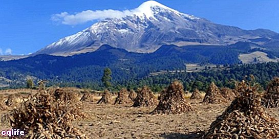
- Transverse volcanic axis or the neovolcanic axis. Uniting the two Sierras Madres (western and eastern) and crossing part of the territory of the states of Nayarit, Jalisco, Colima, Michoacán, Morelos, México, Puebla, Veracruz, Tlaxcala and the DF (Federal District), this rocky mountain range consists of a set of volcanic rocks, magma spills and other volcanic phenomena dating from the Cenozoic.It has a length of 900 kilometers (from the Gulf of Mexico to the Pacific coast) and an average width of 130 kilometers, with average heights of 2,500 meters above sea level. Two of the largest rivers in the country are born in the region, such as the Lerma and the Mezcala, and there are some of the most famous active volcanoes in the world, many of which reach very important heights, such as the Pico de Orizaba ( 5,650 masl), Popocatepetl (5,450 masl), Iztaccíhuatl (5,280 masl), Nevado de Toluca (4,560 masl) or Malinche (4,460 masl), to name just a few.
- The Yucatan Peninsula. Located in the south of the country, and containing the states of Yucatán, Quintana Roo and Campeche, it consists of a platform of underwater rocks emerged millions of years ago. It is a relatively flat region, with the exception of the Sierra de Tucul, which is low in height, and its most notable topographic feature is the set of underground caverns through which the water flows to the north. In this underground drainage network there are many cenotes, uvalas and holes, exploited for tourism. The region contains the rivers El Palizada, El Candelaria, El Champotón and the Río Hondo, as well as the extensive lagoons of Bacalar and Chinchancanab.
- The Sierra Madre del Sur. Extending through the states of Jalisco, Colima, Michoacán, Guerrero and Oaxaca, this mountain system is much more complex than the two large ones that exist higher up (western and eastern), since its rocks have a very diverse geological origin, with ages from 600 million years, up to "younger" rocks of a million years. In addition, rocks of all three types abound: igneous, sedimentary and metamorphic. To the north, it presents an important depression, known as the Valley of Oaxaca and the Balsas depression. In addition, it is limited to the north by the transversal volcanic axis and to the east by the Isthmus of Tehuantepec.
- The southern Gulf coastal plain. Covering the coasts of Veracruz and Tabasco, and close to the Sierra Madre Oriental, this deep-soils plain is present at the mouth of the Grijalva, Usumacinta, Papaloapan and Coatzacoalcos rivers, one of the largest in Mexico. Towards the northeast they present floodplains with permanent swamps, and towards the coast a mountain range known as the Sierra de los Tuxtlas, which interrupts the landscape.
- The Sierra de Chiapas and Oaxaca. Extending through northern Chiapas and southern Tabasco, it is a group of mountains that is commonly divided into two separate but geologically similar systems:
- The Sierra Madre de Chiapas, of little extension (280 km), but important height (2,500 meters above sea level), presents plains and depressions towards the border with Guatemala, where the Tacaná volcano is located. Many of its plains are watered by the Chiapas River.
- The Sierra Madre de Oaxaca, located entirely in that state, is considered an extension of the Sierra Madre Oriental that occupies about 300 km between the Pico de Orizaba and the Isthmus of Tehuantepec.
- The Mountain range Central American. Occupying part of Chiapas and Oaxaca, this mountain range extends to the Central American nations, where it reaches greater heights and complexities. In Mexico, its elevations vary between 900 and 2,000 meters above sea level, rising especially in the region of the Tacaná volcano (4,117 meters above sea level), while towards the coast there are discontinuities marked by the presence of lagoons, that is, coastal lagoons separated from the sea.