- What is continental drift?
- Evidence for continental drift
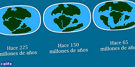
- Stages of continental drift
- Continental drift and plate tectonics
We explain what continental drift is, who devised the theory and what evidence exists today. Also, what is plate tectonics.
What is continental drift?
Continental drift is the gradual but constant displacement of the different continental masses of the planet Earth with respect to the others, moving away or approaching in a cycle of millions of years.
It is due to the viscous and semisolid nature of the terrestrial layer underlying the lithosphere superficial. On it float the different tectonic plates, pushing and moving reciprocally, like rugs on a waxed floor.
The current location of the continents it is different from that suggested by geological evidence from the fossil record. As an explanation for this difference, the theory of continental drift was proposed in 1912 by the German geophysicist Alfred Wegener (1880-1930).
At the time the theory was met with skepticism by the geological community of the time. However, in the 1960s, with the understanding of plate tectonics, continental motion could be more adequately explained.
On the other hand, the idea that the shape of the continents fit together like pieces of a puzzle is not new. In the 19th century the German naturalist Alexander von Humboldt had already theorized about it.
Some 50 years later, the French scientist Antonio Snider-Pellegrini came to the conclusion that the presence of the same fossil evidence on the coasts of continents as far away as Africa Y America It had only one explanation: that they had once been communicated, either physically or through land bridges that were now submerged.
The first complete explanation of this phenomenon came with Wegener, as well as the name of the supercontinent that together all the current ones formed: Pangea (from the Greek bread, "everything and gea, "Earth").
Evidence for continental drift
There are numerous tests of continental drift, such as:
- The coincidence of the shapes of the different continents, observable on a world map, and which is even greater if the limits of the continental shelves are observed.
- There is geological evidence of the closeness of the continents, since many rocky or mountain formations have the same age and the same type of stones (evidence of the same type of metamorphic processes) on continents that are distant and different today.
- The presence of fossils of plants Y animals on the coasts of continents today separated, it is perfectly explained if the continents were closer together before.
- Paleoclimatic analyzes that use subsoil rocks to determine the ancient climate of some regions of the earth's surface are meaningless in a continental distribution such as the current one. Instead, in a unified continent they are perfectly possible.
Stages of continental drift
Pangea was not the first supercontinent. Before there were others, which were separated into pieces from which other supercontinents were formed, and so on until today. This process can be roughly summarized in the following stages:
- About 1,100 million years ago. The supercontinent of Rodinia was formed, the first great block of land from which all the continents came. The possibility that there were some previous continents is not ruled out, but there is insufficient evidence to confirm it.
- About 750 million years ago. Rodinia began to fragment and a new supercontinent emerged from its remains.
- About 600 million years ago. This second supercontinent, called Pannotia, was realized, which had a relatively short life of 60 million years.
- About 540 million years ago. Pannotia fragmented into two smaller supercontinents: Gondwana, to the south, made up of what is now Africa, South America, India, Oceania, Madagascar and Antarctica; and Proto-Laurasia, to the north, made up of Asia, Europe and North America. Between them a new ocean was formed: proto-Thetis.
- About 500 million years ago. Proto-Laurasia was divided into three new continents: Laurentia, Siberia and Baltica, allowing the creation of two oceans new: Iapetus and Khanty.
- About 485 million years ago. In the Ordovician period, a microcontinent separated from Gondwana: Avalonia, corresponding to the present United States, Nova Scotia and England, and began its journey north, until it joined Laurentia. Thus, Baltica, Laurentia and Avalonia collided to form Euramérica.
- About 440 million years ago. Gondwana began a slow movement from the south that led it to collide with Eurasia, losing on the way the microcontinents of North China and South China, which went their own way. Like them, other fragments broke away and gathered in new locations, as the oceans closed and the continents approached again.
- About 300 million years ago. During the Permian period, there were only two major continents: Siberia and Pangea, close to each other, and surrounded by a single ocean: Panthalassa.
- About 251 million years ago. In the Triassic period, there was a great marine recession and the increase in landmass, along with continental drift, unified the continents into Pangea, a gigantic C-shaped supercontinent, with the Sea of Tethys in its interior.
Continental drift and plate tectonics
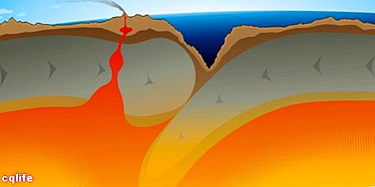
Today, Wegener's theory constitutes a predecessor of what we understand as Tectonic plates, a concept in which it is also included. The latter was formulated in 1960 by the studies of Robert Dietz, Bruce C. Heezen, Marie Tharp, Harry Hess, Maurice Ewing, Tuzo Wilson, and others.
Plate tectonics explains the movement of the continents in the convection of the mantle of planet Earth, whose movements constantly reconfigure the upper and rigid layer, the lithosphere.
In this way, both continental drift and the expansion of the ocean floor are the result of a long process, of billions of years, that mobilizes and confronts the fixed plates of the Earth crust (tectonic plates), which can consequently present deformations, giving rise to the birth of the relief.