- What is hydrography?
- Hydrography characteristics
- Importance of hydrography
- River uses
- Hydrography and hydrology
- Hydrography in Mexico
We explain what hydrography is, its importance in geography and its characteristics. In addition, its relationship with hydrology.
What is hydrography?
Hydrography is a branch of the geography who is dedicated to the systematic description and study of the bodies of Water of planet, especially of continental waters, that is, of the water resources of each specific region. In this sense, it is close to other geographical disciplines such as hydrology, geomorphology, oceanography and climatology.
The disciplinary approach to hydrography comprises two well differentiated branches:
- Marine hydrography. Specialized in capturing and studying information about him ocean: the ocean floor, coasts, tides and streams, and especially the way to capture all that information cartographically.
- Hydromorphometry. Dedicated to the study of hydrographic basins: their shapes, dimensions, composition, etc.
The term hydrography comes from the sixteenth century, as an attempt to establish a analogy with geography, but applied to the percentage of the world that is underwater (geo = land / hydro = water). However, throughout the history, is discipline It demonstrated its usefulness not only theoretically, but also applied to the cartographic as well as to the economic and military.
For this reason, it is part of the national geographic services of most countries. There is even an international hydrographic information network, run by the Hydrographic Organization, founded in 1921 and based in Monaco.
On the other hand, the term hydrography is used to name the set of water resources of a region determined.
Hydrography characteristics
Hydrography:
- He focuses his studies on continental water resources, without excluding everything related to the sea, without entering the specialized fields of disciplines such as oceanography.
- He shares his interests with other geographic and cartographic branches, especially with regard to understanding the natural resources of each region. However, this approach should not be confused with that of hydrology, dedicated to the study and distribution of the waters present in the Cortex and the atmosphere terrestrial.
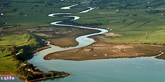
- He is interested in issues such as watersheds, river sedimentation or watersheds. In short, it is interested in the way in which inland waters flow into the oceans and endorheic lakes.
Importance of hydrography
Hydrography is a science It is fundamental for the use of the water resources of a given geographic region, which together represent a very low percentage of the total water on our planet, so they must be managed with a scarcity criterion.
On the other hand, hydrographic information is key to the best and most accurate knowledge geography of regional geography, which in turn brings economic and military advantages over those who ignore the world around them.
River uses
From the hydrographic point of view, rivers have the following uses and uses:
- They allow irrigation, a key activity in the developing of the farming, which translates into better and more abundant generation of food.
- They allow river navigation, which is a way of transport extremely practical in nations devoid of marine coast, or even in those that combine their coasts with rivers of good size that allow the merchandise to reach the interior of the territory.
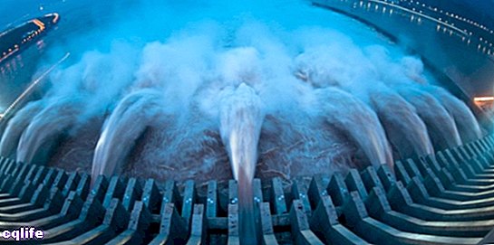
- They allow the generation of hydroelectric energy, through the construction of dams or the use of natural waterfalls to install turbines moved by water. This type of Energy it is extremely economical and reliable.
- They are suitable for fish farming and fishing, which are economic activities that also provide food to the population.
- They have recreational uses, such as swimming, water sports and spas, which affects the culture and in the sightseeing.
- They have mining potential, since rivers tend to carry valuable minerals that can then be filtered or collected in different ways.
- They provide abundant water for various chemical, construction or manufacturing.
Hydrography and hydrology
As we said before, both hydrography and hydrology share certain specific contents, but they do so from very different perspectives and contexts.
Hydrography focuses on the understanding and recording of the water resources of the continental crust and / or the oceanic crust, from a perspective very close to geography.Instead, hydrology deals with the distribution and properties of water on the planet, both in soils, the oceans, the atmosphere and the glacial masses.
Thus, the meeting point of both disciplines is constituted by rivers and seas, but hydrology goes much further, as it aspires to be, basically, the science of water on our planet.
Hydrography in Mexico

The Mexican nation has a vast network of waters up to 600 kilometers long, which includes rivers and other surface sources, which cover approximately 60% of the total territory.
Added to this are large underground deposits (95% of the total Mexican water resources), which provide around 75% of the water for human consumption, since the climatic differences between the different regions of the territory produce marked differences in terms of humidity.
Thus, the north of the country is much more arid, with scarce rainfall and stationary water presence, while in the south the rains are more constant, given its humid tropical climate. This configuration makes access to the drinking water one of the main difficulties faced by the Mexican population, especially those who live in remote regions.
On the other hand, Mexico has important coasts both in the Atlantic Ocean (the Gulf of Mexico) and in the Pacific, and an important chain of lakes and lagoons, many of them of volcanic origin. It also has important rivers such as the Bravo, Lerma, Yaqui, Balsas, Mayo, Colorado, Papaloapan, Istmo, Tonalá, Pánuco and Usumacinta.